| Reservoir Walks Piethorne Valley - April 2011 |
Reservoir Walks Piethorne Valley - April 2011 |

 Decisions, decisions...
|
Statistics
Location:
The Piethorne Valley
OS Grid Reference: SD960124
(Copy and paste into the "Place, postcode, grid-ref" box)
Type:
Compilation
Date:
19 April 2011 to 30 April 2011
Time:
26 Hours
Total
distance: 43.79 Miles (Including corrections for
changes in altitude)
Altitude:
Min:
658 feet
Max:
1260 feet
Difference:
602 feet
|
The Piethorne Valley, in the south pennines, is part of the Piethorne and Castleshaw Estate owned by United Utilities, It has six main reservoirs and several woods in its boundaries, but is mainly moorland.
It is situated on the A640 between Newhey and Denshaw. Rochdale and the M62 are to the north, Oldham is to the south.
Information on the area seems relatively sparse. As United Utilities own the whole area, visitors have to play by their rules, which in this case means no hot-dog stands, ice-cream vans, caravans or yobs. So unlike the tourist attractions of Hollingworth Lake and Dovestone Reservoir you get peace and quiet. It's ideal for fishing, walking, horse riding and photography. Just remember to bring your own food and drink.
Sometimes, the ranger station by the car park and toilets (which has facilities for the disabled) puts out leaflets detailing walks in the area, which I've made available as PDF files in the links below.
|
For further information search for "The Piethorne Valley" and see:
Piethorne Valley Walk No 1
Ordnance Survey Map - South Pennines - OL21
(OS shop)
British Towns and Villages Network - Denshaw
Geograph - SD9612 - Piethorne Reservoir
The Woodland Trust - Old House Ground Plantation (aka locally as Bluebell wood)
Wikipedia - Piethorne Reservoir
|
As well as concessionary paths there are also numerous social trails, the Pennine Bridleway, Rochdale Way, Oldham Way and public footpaths. Further afield are the Tameside Valley Way, Crompton Circuit, Standedge Trail and Pennine Way - enough to keep you busy for quite a while...
As the trails pass over rough ground and stiles, wheelchair access is virtually negligible, BUT there is a ramp that can be used to get limited access to Ogden reservoir. Generally, it can be rough going in places, so is not suited to anyone who has difficulty walking, and due to the rough nature of the trails, ideally you need boots.
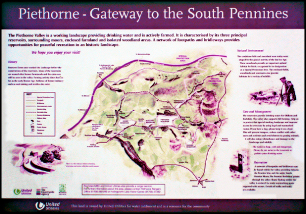
There is a notice board in the car park which holds the map below. It's a bit faded unfortunately but still readable, however you're better off with an OS map.
|
Click on the images below for large printable maps.
|
|
This
one's courtesy of OS OpenData.
|

|
If you have "Google Earth" installed, click on the link below and choose "Open" for a bird’s-eye view.
|
Google Earth - Piethorne Valley - 22 Apr 2011
|
The link centres on the location of the car park and toilets by Ogden reservoir and the ranger station. You can also park on the road, but be aware of the restrictions by United Utilities.
The image below shows some of the walks I've done. You're not supposed to wander around the two reservoirs at the right-hand corners, but hey, you know...
|
|

|
The pictures below have been geotagged with data from a GPS data logger, using the smashing FREE utility
GeoSetter.
It can also be used to geotag your own photos manually so that you can show their location on a satellite map in
Google Earth etc.
Clicking on an image invites you to "Open" Google Earth at the image
location. Clicking the "pin" will display the image.
|
Remember:- "Take nothing but photographs.
Leave nothing but footprints"
That's the intro over

|
As this is a moor in the pennines, the weather can change in a matter of minutes. It's also colder and windier at the top of the moor so you need to carry warm clothing. You can see the Windy Hill transmitter mast from here, so expect... wind.
This covers several of my walks here, so I'm just showing interesting or informative views - the whole area is simply too big to do in one go.
There are no seats or tables around - it's not a park - but there's nothing to stop you picnicking, and there's a pub / restaurant called "The Bulls Head" on Lanebottom which advertises its "menu" on notices in the car park...
When I first got here the notice board map in the car park was really manky, so I cleaned it up a bit with a biocide to get a picture as I couldn't find it online. I wore a hi-viz to look official . The before and after...
|
|

|
|
With the "Community Service" done, it's time to go for a walk so let's head up the steps to Ogden reservoir.
|
|

|
|
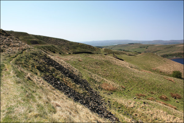
At the top of the steps you start to get an inkling of the scale of the area - the huge but barely visible spillway at the far end of this path is 1/5th of a mile away...
|
|

|
|
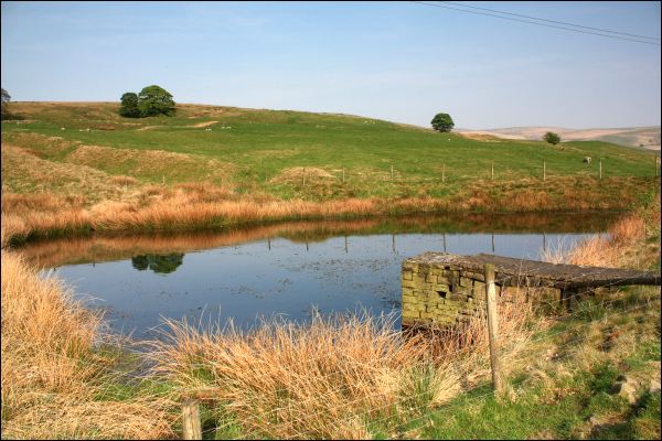
On the left is Foulwater Lodge. Despite the name, the water's clean and is kept topped-up by overspill from the reservoirs. There's a gap in the dry stone wall by the path at the bottom of the embankment which allows access to the flat grassed area behind it, where the staff from the works below it have their lunch in good weather.
|
|

|
|
On you right is Ogden reservoir. The dry stone boundary walls have been built with projecting stones that you can use as steps to reach the water's edge - popular with fishermen.
|
|

|
At the far end of the path after crossing the bridge over the spillway you have to negotiate this path and a crotch bruising stile through the dry stone wall.
The lack of rain this spring has left the reservoir levels pretty low, so no pictures of torrents cascading down the spillways I'm afraid.
|
|

|
|
If you go left after negotiating the stile, you can go round the woods (Rough Bank plantation nature reserve) to the north-west, but there's not much to see there as any view is spoiled by Dick Hill. Going right eventually leads you to this little bridge at Rag Hole Clough - and the deceptively steep cobbled path at the other side...
|
|

|
|
A quick look around and...
|
|

|
|
Near the top of the path are the ruins of Rag Hole farm.
|
|

|
|
The path eventually forms a T junction with Tunshill Lane. The right hand path heads towards Kitcliffe and Piethorne reservoirs. Along the way there is this pond formed by drainage off Town Hill...
|
|
|
|
...and this barn at Spring Holes, which could be used as a shelter in an emergency. Owls have been known to nest in here in winter...
|
|

|
|
...and this mini-quarry which is used to provide fresh stone for repairs.
|
|

|
|
Ah! some distant wildlife in the shape of a meadow pipit...
|
|

|
|
...and this birdie, which I'm not sure about.
|
|

|
|
A little further on you come across what looks like someones rock garden in the middle of nowhere...
|
|

|
Taking pictures of the next reservoir - Kitcliffe - isn't easy from here, as you're facing the sun. The best vantage point would be from the west edge later in the day, but access is blocked by houses and fences to the south and west, and a spillway to the north. There is access to a fishing area between the house and Piethorne water treatment works at the south, but movement to the east is blocked by overgrown shrubbery from the houses gardens. In other words, the house owners have managed to isolate the area for themselves - the lucky b*******!
However, I have spotted this at the north-west corner, and a United Utilities land ownership map shows a path - as does Google Earth - which merits future investigation
|
|

|
A few yards past the rockery you come to the bridge over the Norman Hill catchwater, which also gets water pumped into it from the Old Butterworth Hall colliery workings, and Piethorne reservoir spillway.
The gates are kept locked to prevent unauthorised vehicles, so to continue on the path north of Piethorne reservoir you can either scale the gate or use the path formed by the gratings at the left.
|
|

|
|
Before that, a look to see if there are trolls under the bridge, and a short detour between Kitcliffe and Piethorne reservoirs. As with Ogden reservoir, the water levels are pretty low so no waterfalls in the spillways, but the sheer size should indicate what happens in heavy rainfalls.
|
|

|
|
A little way down the path between the reservoirs there's a pump house...
|
|

|
|
...and someone trying to catch his dinner...
|
|

|
|
...in Piethorne reservoir.
|
|

|
|
It's possible to get a picture of Kitcliffe reservoir from here as long as you don't leave it too late.
|
|

|
|
But back to the bridge. If you use the path at the left of the gates you have to cross the catchwater channel to get back on the main path - easily done as there's only a trickle of water in it so far.
|
|

|
|
As you continue down this path you become aware of the mixture of noise of leaking compressed air and splashing water. Crossing this little bridge over the catchwater...
|
|

|
|
...reveals the culprit, which is part of the Old Butterworth Hall colliery pumping system...
|
|

|
|
...and this is where the water goes. The banks aren't too steep, so if you like fishing...
|
|

|
|
Further along you see the water drained from Norman Hill reservoir and Cold Greave Clough - and the gate leading to Cold Greave Clough.
|
|

|
|
Go through the gate and turn left and you see "The Waterfall" - spillway - from Norman Hill reservoir, but as with the other spillways, there's not much of a waterfall at the moment.
|
|

|
|
Head for the waterfall and you'll find the path blocked by a locked gate. No problem, just climb over the gate and follow the path up to Norman Hill reservoir. It's not far, but the path's steep enough to make you wheeze. Note the transmitter mast on the horizon in the centre of the picture. It's the "Windy Hill" transmitter mast, and is only about 1.25 miles away, so you can guess what it's usually like up here.
|
|

|
It's only a quick visit this time to find out how accessible it is. Google Earth shows a path at the left of the reservoir - which is below the line of site from here - and social trails at the far end, one of which leads to the catchwater that supplies Rooden reservoir, but that walk is for another time.
You can tell these structures were built in a different era - purely decorative arches and stonework like this was never meant to be seen by the general public. These days it would probably be a single concrete block.
|
|

|
|
The next reservoir to see is Hanging Lees. The water isn't visible in this view from Norman Hill reservoir, but it's just above the centre. The path leading up to it looks like a gentle slope, but isn't.
|
|

|
|
Back down past Piethorne reservoir we go, only to see the spillway leading from Cold Greave Clough.
|
|

|
Past the Piethorne pumphouse - where the dry stone wall is at a convenient sitting height - the path starts to climb towards the catchwater leading to Rooden reservoir. Looking back, the gate and stile on the left leads past Hanging Lees, Piethorne, Kitcliffe and Ogden reservoirs and back to the car park.
But that path's for wimps - it's time to tackle...
|
|

|
|
...the lung buster.
|
|

|
|
It doesn't flatten out, just curves round a bit, but if you survive this, you get a cracking view back down Cold Greave Clough towards the "Waterfall" - the tiny dark bit in the middle of the picture - and the moors beyond it. What doesn't kill you makes you stronger
|
|

|
|
Carry on up the hill and take a right at the bridge to get onto the path by the Rooden catchwater. Is there something special about the grass here, that the sheep go to so much trouble to get at it ?
|
|

|
A left turn at the bridge would take you towards Norman Hill reservoir and Windy Hill. There's an SSSI up there by Cold Greave Clough which I'll visit next time.
The good thing about this path by the catchwater is that it's virtually flat, so it's time to take get your breath back and have a butty and drink from the victuals you brought with you. What do you mean 'you didn't bring any' ? You read this blog before you did the walk didn't you ? You must have seen the warnings about the hills, yes ? You must have known to bring a drink ? Wait a minute, are you wearing trainers ? Oh for god's sake, where are your boots !?
The views from up here are great. You can even see the windfarm 10 miles away, if you really want to. I prefer the view of Hanging Lees and Piethorne reservoirs myself.
|
|

|
|
As you approach Rooden reservoir, you come to a little blue painted bridge across the catchwater and a trail that can take you a little higher onto the moors. It's worth the extra effort as you can look back at where you've been...
|
|

|
|
...as well as down onto Rooden reservoir and its surroundings, to give you more of an idea of what to do next. Despite appearances, there's a path all the way round...
|
|

|
|
...if you're prepared to climb over gates and fences, and ignore this sign.
|
|

|
Although you could always chicken out and slink back to the car park 
Before tackling the gates and fences, it's time for another break as a bit of cloud and haze has crept in. A look at the sky indicates it could clear up in ten minutes. This hill has a few wheatear ground nests in it. so be careful where you sit...
|
|

|
|
...and photograph them.
|
|

|
|
The gate just in view at the top left is where the "Access Land" ends, but once you've climbed over it you'll see...
|
|

|
|
...llamas...
|
|

|
|
...being naughty!...
|
|

|
|
...and Meadow Pipits...
|
|

|
|
...and Pied Wagtails...
|
|

|
|
...and the usual suspects...
|
|

|
|
...and Little Owl pellets, but no owls in sight unfortunately...
|
|

|
|
...Oh, and Rooden reservoir...
|
|

|
|
Now that we're here, we might as well have another coffee break before heading back to the car.
|
|

|
|
|
|

|
|
You have a choice of paths leading back to the car park, but the lane at the "End of Access Land" sign would be too easy. So, as we're hard, we'll take the clearly defined path halfway up this hill. No need to worry about losing your footing, as the rocks will break your fall.
|
|
|
|
Another view of Hanging Lees reservoir. The path you can see is part of the easy way down from Rooden reservoir. We're heading for a stile at the left corner of the reservoir to join that path, which leads to Ogden Lane.
|
|

|
Thought it was all over, did you ? No way !
By Kitcliffe reservoir there's the Piethorne Plantation. You can hear all manner of bird tweeting here, but getting a photo isn't easy. Luckily this robin posed for me...
|
|

|
|
...while this Great Tit hid in the shadows by Ogden reservoir...
|
|

|
|
...before flitting to a twig and scarpering.
|
|

|
|
A few yards further on this youngster just stared at me.
|
|

|
|
Ogden reservoir seems to be a haven for Pied Wagtails that patrol the waters edge looking for insects. They never let you get close, and won't stay still for long. This one was an accidental capture.
|
|

|
|
This bee was checking out gaps in the stonework - probably looking for a new home. Just how can a bee so large fly with wings so small ?
|
|

|
|
Finally, if the hills get to be too much for you, at least you can have your last rest here.
|
|

|
It's a lovely area with non of the hustle and bustle of better known tourist attractions, with free parking, clean toilets, and people who say "hello" instead of "hiya". If you like challenging, isolated walks, you ll love this place.
Rumour has it that a grand total of up to 156 species of birds have been seen around here over the years. I saw Oystercatchers at Rooden reservoir on my first visit. The reed beds below the embankment at the south-east corner of Rooden reservoir seem to be a magnet for all manner of bird life.
There's far more to it than I've been able to show, such as the woods at Wickenhall, Woodside, Knowsley and the Old House Ground Plantation as well as the walk around Tunshill lane - where you can detour along the Pennine Bridleway under the M62 all the way to Hollingworth lake. I've not included them here as they would triple the size of this blog. And you could also head south-east towards Crompton Moor and Castleshaw... Maybe next time...
Hope you enjoyed reading about it, and thanks for dropping in.
Richard.
|
Acknowledgments:
Contains
Ordnance Survey data © Crown copyright and database right 2011
OS
OpenData FAQ
Q. What licence applies to OS OpenData products?
A. The licence
allows the full reuse of the data freely and flexibly, with only a few conditions.
|
| Reservoir Walks Piethorne Valley - April 2011 - Compiled on 06/10/2019
|
|
|
Constructed with Autoblogger v5.0.96
|
|

